You Are On Search Vanishing Minot Boom Or Bust Page
This Page Is For All Those Who Had Their Lives Turned Upside Down In 2011 - For All Those Who Suffered Chronic Stress Leading To Illness & Demise - For All Those Who Still Suffer
There Is No Excuse For The Epic Mismanagement Of The Dams On The Souris - For This All Could Have Been Avoided - Had Someone Managed Those Dams - Had Someone Taken Control.
There Has Never Been Proof Of Concept Of Management Of These Dams - As FEMA Director Brock Long Asked Is There One Person I Can Call Who Runs These Dams - Never Has Been
All The Reports - All The Studies - Lead To The Same Conclusion - The Dams Work - The Humans Managing The Dams Did Not!
Minot Isn't Vanishing Because of the 2011 Flood - Minot is Vanishing Because of Flood Control & Taxes - Vanishing People, Property, and Money
All the "Dams Of Contention" did in 2011 was create a mismanaged mountain of water
To cause a mismanaged flood to Minot that was less water then 1976! - Bad Math & Magic
Minot came into existence in 1886, when 'James J. Hill', Great Northern Railway ended its push through the state for the winter. After having difficulty constructing a trestle bridge.
Across Gassman Coulee. It was the end of the railway's line. So whenever a train came into the town and the stop was announced, the conductor would call out,
"Minot, This Is Minot North Dakota, Prepare To Meet Your Doom". Even Then There Was Controversy
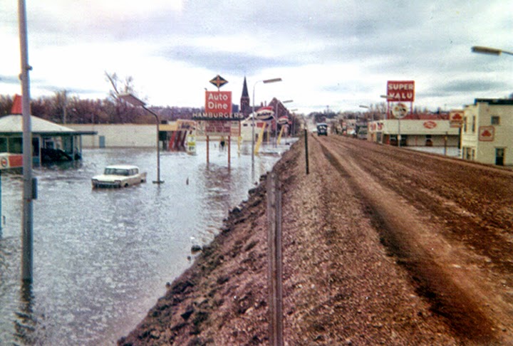
The Real Fact - In the spring of 2011 the residents below these three dam's had no idea and were never told of the ticking time bomb of water above them.
They were in harm's way and a storm of bureaucracy on both sides of the border left them to unmanaged volatility of the Souris River not seen since 1976
The Dam's Were Not Just Full - They Were At Dangerous Above Full Level's In April Of 2011- Facts Rumors Link
2020 - The Operating Plan Has Not Changed - Still Not Hooked To Inflow Or Measurement Of Water On The Ground If The Canadian's Wont Match Outflow To Inflow
At There Dam's Then Why Dont The American's Just Do It At Lake Darling? There Dam's Are Full So Just Dump Whatever is Coming Into Them - They Wont Do It!
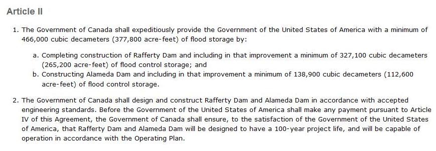
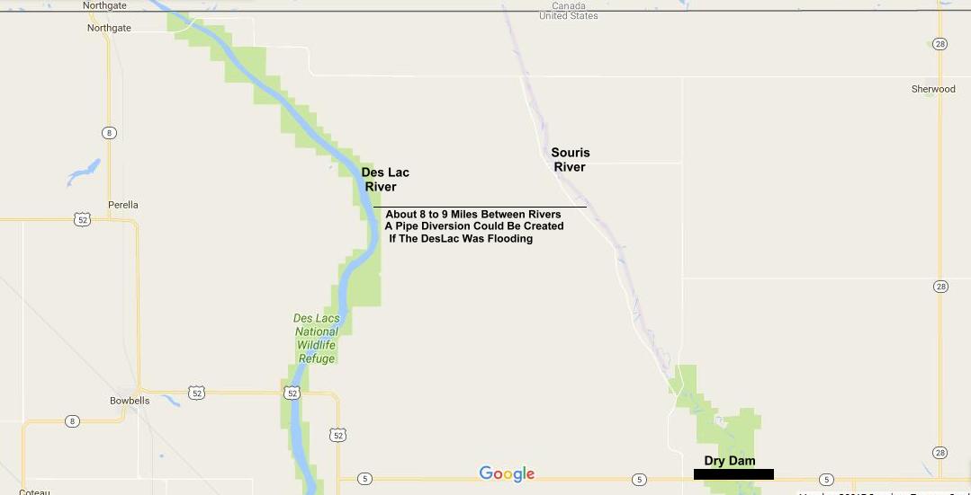
The Burlington Dam Capacity would have been 633,000 acre feet, plus a raised Lake Darling of 110,000 acre feet (1977 Price Tag Of $92 Mil. For Both) - and the 377,800
acre feet in the agreement. Giving you 1,128,000 acre feet of storage, you could have contained the 2011 flood with some take action management. - USGS & Links
Return To Minot Bakken Real Estate Boom Or Bust Page
| Vanishing America - Minot Return To Top Of Page |
Vanishing America - Minot ND Is Disappearing?
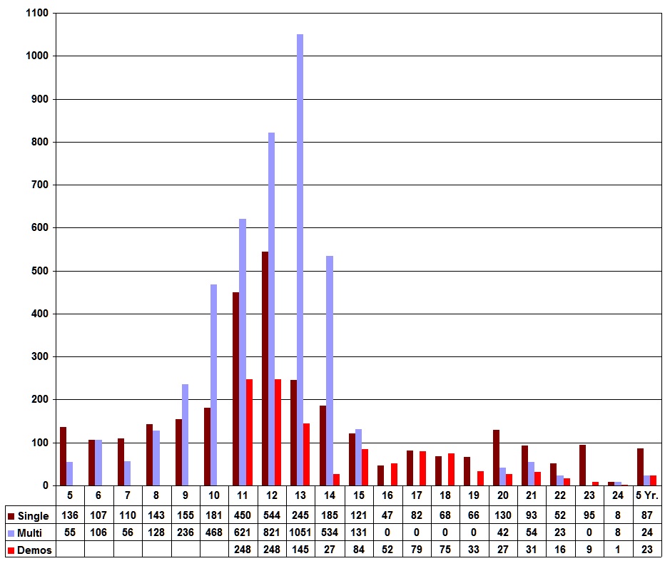
Minot Actual Permitted Home Demolition's
2011, 248 - 2012, 248 - 2013, 145 - 2014, 27 - 2015, 84 - 2016, 52 - 2017, 79 - 2018, 75 - 2019, 33 - 2020, 27 - 2021, 31 - 2022, 16 = 1064
Cannot Find Numbers For 2011 - 2012 - The NDRC Application March 6th 2015 Page 18 - States That 805 Homes Were Destroyed By The 2011 Flood
In Fact In 2016, 2017, 2018, More Homes Were Tore Down Then New Ones Built
The Gross 1018 Units Would Reflect Back Into 2012 As Peak
In Fact In The Last Seven Years You Have Tore Down More Homes - Then You Have Built New Ones
Trying to Find A Real Number Of Homes & Mobile Homes Demolished Since the 2011 Flood Is Hard To Do - Upwards Of 400 Mobile Homes & 350 Stick Homes Gone - Poof
Weather Channel Vanishing America
1

If Shaun Sipma & Miranda Schuler Do Not Like The Context Of The Final Product Then Why Did They Say What They Said
Sipma - "Flood Water Wiped Out A Quarter Of Our City" Poor Choice Of Words - Wiped Out!
Schuler - "We Have To Acclimate Ourselves To The New Normal The New Normal It's Not The Same"
That Would Imply Climate Change Or The Canadian's Make Minot A Very Un-Normal Place
Both Sipma & Schuler Are Or Were City Council Members - Go Figure - Why Did They Ever Consent To This Stupid Stupid Crap
They Are Or Were The Voice For The Taxpayers Of Minot - Unreal
2018 - 2022 Sipma was Mayor & Schuler was a School Board member.
If As Sipma States 25% Of Minot Was Wiped Out & Minot Has Grown 25% Since The Flood - Then Minot Hasn't Grown At All
Sipma Is Or Was The Spokesman For Make Minot - He Made Minot All Right - Spokesman
Face Book Comments - Ryan Bent - Minot is not vanishing! The only reason the weather channel is saying it is because Miranda Schuler is a total and complete twit and idiot.
The only thing that is vanishing is the homes that are being destroyed for flood protection this town doesn't need!
Carolyn Moore - Wow. Sensationalizing news much, Weather Channel? I live in Minot, my home was flooded along with 4200 others in June 2011.
This is not some ongoing issue; in fact, the cause of the flooding that year was ultimately man-made, thanks to the poorly planned international treaty
that dictates the flow along the Souris/Mouse River and the failure to adjust to high volume snow-pack. That's the real story here, in case you want the actual facts...
Got To Have Power For The AC In Montreal
Bottom line: people are NOT abandoning their homes. In 2011, most homeowners took on SBA loans and rebuilt. There have been some home buyouts for future flood protection,
but those number in the dozens, not hundreds. This is not some situation creating a "vanishing city"--in fact, it highlighted what a strong people the city of Minot are.
We dealt with it, we worked hard, and we are proud of our resilient spirit. Any other notion you propagate here is simply hogwash.
Yes Debt Ridden Taxpayers With Upside Down Values - Buyouts In The Dozen's! - Try About 70 Dozen's
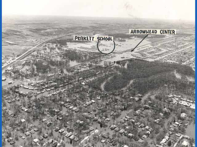
Kind Of Hard To Miss The Hundreds Of Vacant Lots From Homes Tore Down & Trailer Parks Removed
Whole Neighborhood's Are Gone - Empty Lot's - Lives Ruined - Stress That Was Unbearable - Over One Billion & Fifty Million Spent On Crap & Not Taxpayer's
It Is Unimaginable That Dave Malkoff Is A Award Winning Reporter - As Usual No One Bothered To Vett Him - Always The Hype
He Played Them For Fools & They Took It - Hook, Line & Sinker
Dave Who?
| First
Round Demolition's |
Second Round Demolition's | Third Round Demolition's |
Minot City Council To Act On Optional Upside Down Flood Home Buyout Policy
It just gets deeper and deeper, it is insanity at a new level!
| Buyout
Policy |
How Many Upside Down Homes | Foreclosures & REO In Minot |
Is Minot Buying & Demolishing Home's That Are Not In The Flood Plain - Or Part Of The Buyout Path For The Enhanced Illogical Flood Plan?
Some Question Acquisitions
Minot - Single - Multi - Demo - Family Building Permits - 2005 to Current
| 2011 Flood Report - The
Dams Were Full Return To Top Of Page |
Yes The Canadians Had Been Hoarding Water In The Dams Since Early Spring For Their Coal Fired Generating Stations
Temps In The East Were In The 80's & 90's Back In April 2011 - The June Rain Event Overwhelmed Storage So They Flushed The Toilet Downstream
2011 Post Flood Report - Page 42 - First Paragraph
"The
reservoirs
were at or near maximum allowable water levels by early May.
There was pressure on SWA being applied by the City of
Estevan
and Sask Power to decrease the discharges from Rafferty reservoir. The technical representatives for North Dakota were also asking for reductions."
Page 22 - 47 - No technology is
in the basin to monitor rain fall, yet alone a simple look at
radar and some phone calls and some basic and Sask Power to decrease the discharges from Rafferty reservoir. The technical representatives for North Dakota were also asking for reductions."
math you couldn't have come up with a guess of the amount of water to come into the dams?
Page 48 - the dams were full in early May and no one thought this out, rain after rain.
Pg. 49 - During these rain events from May to mid-June if Lake Darling reservoir had been completely dry and
released no outflow it would have filled to the MAFL four times. During the inflow peak it would have filled every 3.5 days.
Thats incredible, the dams in Canada are full, it is raining and the last dam on the system is being used to play Russian Roulette.
Shouldn't the warning bells have been going off by this time, someone connecting the dots that all hell was going to break loose?
Pg. 52 - During the large
rain event in June if Lake Darling reservoir had been
completely dry and no outflow was released it would have
filled
to the MAFL four times. During the inflow peak it would have filled every 3.5 days. Seems very stupid, the last dam on the system and
it only holds 110,000 acre feet, the treaty agreement calls for 377,800 acre feet of storage, almost 4 times the size of Lake Darling.
Now when that storage is to be held and or created is unclear, is it always to be there or its just part of the Russian Roulette.
For if that storage had been there it would have held Lake Darling capacity 3.4 times.
Lake Darlingto the MAFL four times. During the inflow peak it would have filled every 3.5 days. Seems very stupid, the last dam on the system and
it only holds 110,000 acre feet, the treaty agreement calls for 377,800 acre feet of storage, almost 4 times the size of Lake Darling.
Now when that storage is to be held and or created is unclear, is it always to be there or its just part of the Russian Roulette.
For if that storage had been there it would have held Lake Darling capacity 3.4 times.
| The Treaty
& (Dry) Dam's Of Contention Return To Top Of Page |
Garrison Dam On The Missouri Has Capacity For 23.8 Million Acre Feet - The Corp Couldn't Manage That In 2011 Either
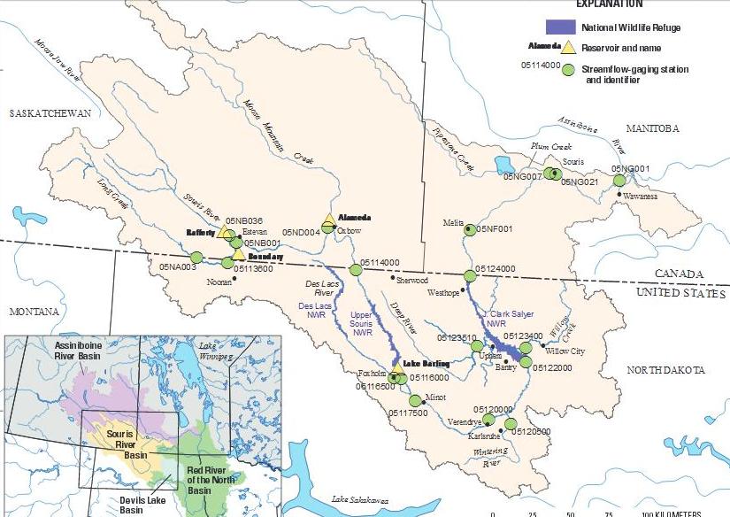
Rafferty Capacity 511,000 AF - Alameda Capacity 152,000 AF - Boundary Capacity 49,100 AF - Lake Darling Capacity 110,000 AF
Total Of 822,100 Acre Feet
377,800 acre feet is or was for the storage of flood water for the USA, that never happened.
Rafferty - Alameda Project
It includes a 10-kilometre diversion channel connecting Boundary and Rafferty Reservoirs, which allows water to be diverted from Boundary Reservoir into Rafferty Reservoir.
The diversion channel can move water either way, you have power plants consuming water at each reservoir.
There is a pipeline from Rafferty to Shand Generating Station at Estevan.
The US had wanted a 1-in-500 years flood design , the technocrats made it a 1-in-100.
| Rafferty - Alameda Project Impact Study | Water
Consumption By Coal Plants |
The Dams That Were Hammered Out On The Fly By "Technocrats"
Preview From - Freshwater Politics In Canada - Pg. 72 to 74
Boundary - The Largest Coal Fired Generating Station In Canada
| Boundary Dam | Estevan
Boundary Dam Please Respect The Copyright of The Author |
| Power
Plants In Saskatchewan |
Power Plants In Manitoba |
Real bad idea to have this much water sitting above Minot and little Lake Darling to hold it back and
No One Is Watching The Ball
The Agreement
The 1986 Agreement Purchasing Storage Pg. 37 - The Raising Of Lake Darling - The End Of The Burlington Dam
The definition of expeditious is - To be done with speed and efficiency
Dry Dam's - No they were never built to be dry dam's another misbelief told to or started by American's.
The long battle over and during construction was the dam's would never fill with water, because of the arid region and drought.
George Hood would swim naked in both dam's when completed.
The Dam's - Politics Not Science
Rafferty being discussed on engineering site - Sask Power & The US Corp
"The initial design, most of the reservoir at Rafferty Dam was for irrigation and power."
The Corp & Sask Power
Page Navigation At Top Of Page
A landmark legal case, an economic panacea, a political boondoggle, a solution to the drought of the century, a sell-out to the Americans,
A boon to wildlife, and an environmental holocaust - all these terms have been applied to the Rafferty-Alameda project.
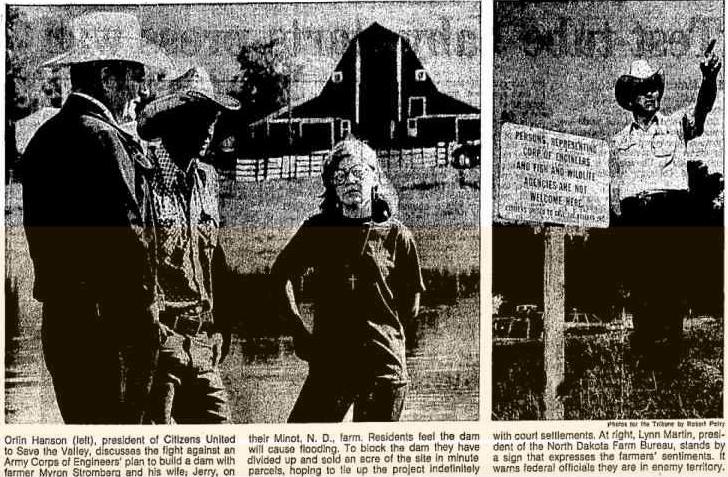
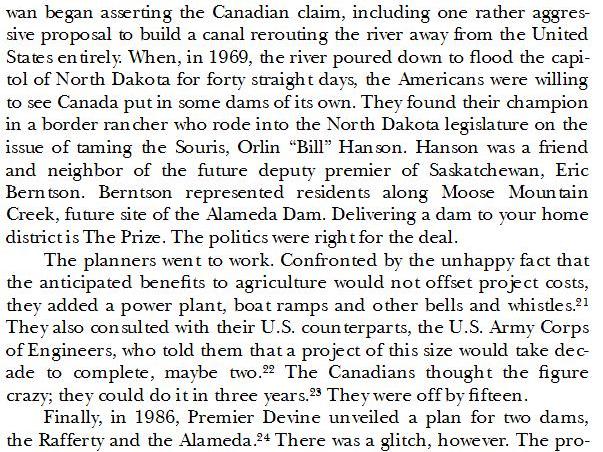
Dam's Of Contention - Burlington - Rafferty - Alameda
The Rafferty & Alameda & Burlington dam's have a very sorted history of contention, going right back to Minot ND
& a man named Orlin Hanson. It is good that he lived long enough to see the end result of his politics.
No Burlington Dam & Minot Consumed By A Flood From The Monster's Rafferty & Alameda He Lived For
The Burlington Dam was on the table. the Des Lac would have been diverted by pipe behind the dam.
The Fed was good to go, also on the table was a diversion channel on the Canadian border and
a 13000 foot long tunnel with a capacity of 9000 cfs to take the Souris River under Minot - Protection Forever Gone
"In 1984, Senator Quentin Burdick of North Dakota urged the U.S. to consider developing flood control near Estevan and Alameda saying it would only cost
the United States half as much as to build its own dam and North Dakota would not lose any agricultural land or have any environmental problems.
Another aggressive American proponent of the Rafferty dam, Orlin Bill Hansen, an elected member of the North Dakota House of Representatives,
testified three times in front of the Saskatchewan government's inquiry into the project, without ever revealing that the Devine government was paying
him $22,000 a year through the agency seeking to build the dam. Mr. Hansen fought hard against building the Burlington Dam a few years ago on the
American side of the border which would have provided flood control for Minot but also would have flooded part of his own ranch.
Mr.Hansen was successful: the project was defeated and now the U.S. government is "helping" build the dam in Canada."
$22,000.00 A Year Was Alot Of Money In The 1970's - $10.58 An Hour - Minimum Wage Was $2.65 An Hour - Good Wage For Contention
The American Connection
The Chicago Tribune - July 23, 1978 - 33 Years Later Minot Is Flood Damaged By His Own Contention Of Dam's
Mouse That Roared - Furor Over Dam
The Chicago Tribune - Oct. 31, 1980
US Gives A Dam - Starts Country Fight Page 1 & 4
My Son, My Son, Walk Along The Mouse River North Of Minot, Walk In The Trees And Drink In The Spirit Of These Primeval Forest Lands
For Soon The Greed Of Man May Destroy Them Forever - Orlin Hanson
Seems strange for a man who's contention of Burlington Dam and his walking and drinking the spirit of primeval forest land's
Would sell his primeval forest land's in 2000. You would think they would have been given to the people as a primeval preserve.

As Printed In Corp's Newsletter - Page 6
They Needed A Champion
| Deputy Premier Eric Berntson | Hanson
& Berntson |
| Berntson
& The Dam's |
Photo Op
Hanson Bernston Olson |
| Dam Good Cake | I Dont Talk To COE |
O Canada The Story Of Rafferty - Page 7. They Found Their Champion
The Needs Of The Few Will Always Out Weigh The Needs Of The Many
| Fact's &
Rumor's Return To Top Of Page |
The MACC Story Goes Against The Facts
Both Rafferty & Alameda Operated At Above Full From April To August 2011
The Real Fact - In the spring of 2011 the residents below these three dam's had no idea and were never told of the ticking time bomb of water above them.
They were in harm's way and a storm of bureaucracy on both sides of the border left them to unmanaged volatility of the Souris River not seen since 1976
The Dam's Were Not Just Full - They Were At Dangerous Above Full Level's In April Of 2011
SWA Annual 2011 Review
"Maximizing the benefit for
any one purpose generally means sacrificing benefits of
another purpose. Stakeholders whose benefits
are not maximized
by operations are often critical of operation decisions
especially if they have sustained damages."
That's A Real Understatement For A Dam Operator
Fact &
Foremost - The needs and safety of the citizens of Minot
should have come first. That's A Real Understatement For A Dam Operator
To get there lives and welfare back in line, not the waste of money on projects that had nothing to due with the flood.
Fact - There is nothing in the agreement about board feet, it's about acre feet and not honored.
Fact - The dams were intended to manage water, not hoard water and increase risk.
Fact - God created the water and Canada and the USA never paid attention to the risk that led up to this disaster.
Fact - It simply did not flow down a river channel, it was mismanaged from the first rain drop.
Fact - The dams were full as of early May - That fact is from the US Corp of Engineer's.
Actually They Were Full In April according to the SWA Annual 2011 review.
From The Local Newspaper's Flood Flashback - 2016
On the second of May Rafferty was a scant two feet from overflowing and a full eight feet higher than the previous record for the reservoir.
Nearby Boundary Reservoir, fed by Long Creek and connected to Rafferty by a diversion channel, was within two and one-half inches of spilling.
Within days Minot would experience the real meaning of the repeated and numerous warnings.
Fact - The Canadian's were at the wheel of the dams and they played it and it got out of control.
Fact - The American's should drop a dry dam on highway 5, west of Mohall and take control of the uncontrolled.
Fact - Who are these technical representatives for North Dakota ?
You should send them the bill for the destroyed health and welfare of the people who lost it all!
"The reservoirs were at or near maximum allowable water levels by early May. There was pressure on SWA being applied by the City of Estevan
and Sask Power to decrease the discharges from Rafferty reservoir. The technical representatives for North Dakota were also asking for reductions."
Fact - Canadian's tend to bypass Minot because of the sale's tax. - Fact - The value of their dollar keeps them from coming down period.
The Story - Flood Fact's
There Wasn't 14 Inches Of Free Board Yet Alone 14 Feet Of Free Board Available In These Dams As Of April, May & June Of 2011
The Dam's Were Not Just Full - They Were At Dangerous Above Full Level's In April Of 2011
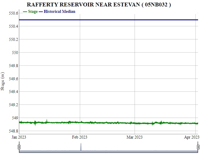
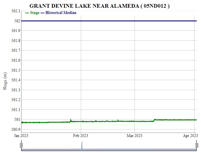
Real Time & Historic Data For The Dams - Daily - Monthly - Extremes - Peak - Real Time - Graph - Table - Source Canadian Federal Govt. - wateroffice.ec.gc.ca
| Boundary Dam
- 05NB012 559.2 Full Level |
Boundary
Canal - 05NB038 Discharge Level's |
Rafferty Dam
- 05NB032 550.5 Full Level |
Alameda Dam -
05ND012 562.0 Full Level |
The USD & CAD Dollar

| Flood
Foretold Return To Top Of Page |
Why do we have all these government agencies and no one cried danger?
"Hints to the devastation in Minot came nearly two years earlier with the rapid saturation of the soils and
the corresponding high river flows for the years preceding the great flood of 2011"
Foretold
I Want My Money Back
Of Course The Page Has Been removed
How could a system of dams (Rafferty, Alameda, and Lake Darling Dams) that were built to minimize or even eliminate the impact of a flood fail?
| Flood
Flashback Return To Top Of Page |
The Local Paper Did A Series Of Stories In 2016 Looking Back At The Time Line Of The 2011 Flood
It is horrifying as to the attitudes of those in the know, in control as to how if they were Frozen In Time to react!
Those in the know were in denial or had not been here in 69 and 76
For When The Mouse River Roars - You Listen!
With this plan of enhanced flood control and an unknown timeline to complete, ask yourself what happens when you have to move more
then 27000 cf's down the valley, what if 35000cfs, 45000cfs, what if an emergency dump of any one of the Canadian dam's.
You Will Flood Minot Again - Not If - Not When - Again
50 years have come and gone and Minot is still the bulls eye for the Souris Basin
The Series Can Be Read At The Local Paper's Website - Or Search Minot Flood Flashback On Google
Flood Flashback
Timeline
February2011
International Souris River Board met in Regina, Sask. Despite the looming possibility of dealing with a “tremendous” amount of runoff,
the City of Minot did not have a representative at the meeting
Where a flood event was declared and control of Lake Darling Dam was transferred to the U.S. Army Corps of Engineers.
The snow pack water content throughout the Souris River Basin ranked among the highest in the previous 60 years.
Minot’s Broadway Bridge was given a 52 percent chance of reaching flood stage.
March 2011
The Corps’ Water Control Office in St. Paul, Minnesota, in charge of releases from Lake Darling Dam northwest of Minot due to 2011 being
declared a more than 1-in-10 flood year by the Souris River Joint Board, seemed to be downplaying the situation.
NWS Hydrologist Allen Schlag made a power-point presentation at the Elmer Jesme Conference of Counties at the North Central Research and
Extension Center on Minot’s south edge on March 28, 2011. No one from Minot City Hall or Ward County government attended.
“We will be looking at cutting back releases from Lake Darling within the next week,” Nelson told the Minot Daily News.
“We’re close to our draw down target so we’ll have to cut back now.”
A few days later residents would experience the beginnings of the greatest and most damaging flood in the history of the Souris River Basin.
April
There was simply too much water in the region and it kept moving, even oozing out of hillsides, despite temperatures well below freezing.
Despite all the indicators that spring runoff could set records, including repeated warnings by the National Weather Service, actual response
throughout the drainage area was slow to materialize. It was almost as though many thought a major flood was an impossibility.
By April 8 the flood control gates at Lake Darling, the final defense against high water reaching Minot, were closed.
Water continued to rise behind the reservoir.
The same day that a record flow of 6,790 cf's was reported in Long Creek.
Long Creek is a tributary of the Souris, a portion of which runs along the U.S./Canada border.
People in the city began to gawk at the river and raise a few questions about what could possibly occur,
but the reaction from City Hall remained unusually low key.
Said the USGS, “This is the highest Souris stream flow in 40 years.”
Clinton Molde of the Saskatchewan Watershed Authority said, “Rafferty Reservoir is filling and not releasing.
The top end of the drainage still has about 100 percent snow cover.”
In Minot there was still no visible reaction to the continued rise of the Souris and the warnings of worse conditions to come.
“We haven’t seen all the runoff yet into Rafferty Reservoir.
The Canadians are seeing water levels they’ve not seen before and I think it is reasonable for changes to occur.”
Despite the reports of historic volumes of water above Minot, it was business as usual in the city.
The Corps announced that releases from Lake Darling would be cut from 4,000 cf's to 3,600 cf's due to a blizzard warning issued for the area.
May
On the second of May Rafferty was a scant two feet from overflowing and a full eight feet higher than the previous record for the reservoir.
Nearby Boundary Reservoir, fed by Long Creek and connected to Rafferty by a diversion channel, was within two and one-half inches of spilling.
Within days Minot would experience the real meaning of the repeated and numerous warnings.
Imagine this, the dam is full and its your main control device on the river and the gates are closed and the snow has not melted yet,
What Were They Thinking!
The capacity of Rafferty is approximately five times that of Lake Darling, the last reservoir on the Souris before it flows into Minot.
The U.S. Army Corps of Engineers announced it would be reducing Lake Darling output to 3,000 cfs
despite the knowledge of vast amounts of water upstream.
Flows of 7,000-10,000 cfs were being predicted at the Sherwood reporting point on the Souris.
Weather forecasts called for rain. Lake Darling releases were cut to 3,500 cfs.
Unable to keep pace with inflows, the Saskatchewan dams increased their releases to 8,472 cfs,
much more than Minot or Lake Darling could hope to handle.
It was just the beginning with much more water to follow, yet little was being done to increase protection in Minot
or by city and county officials to warn citizens of the possibility of record flooding.
“Rafferty is full. Boundary is full. Long Creek is running high and Alameda will be full. Lake Darling is expected to fill.
When you add them all up it’s pretty ugly,” said Allen Schlag, NWS hydrologist.
In the face of such warnings and record releases upstream, the Corps of Engineers cut Lake Darling releases by 300 cfs from 4,000 to 3,700.
The following day the city held its first press conference, supposedly to inform the public with details of the situation.
While some information was shared, city and county leaders announced their opposition to increased releases from Lake Darling.
It was a somewhat confusing and mixed message from City Hall.
“Lake Darling will fill in a few days. The reservoirs on the Souris are full, or nearly full. It’s a dilemma trying to manage this.”
In the face of that assessment the Corps responded with an announcement from its St. Paul office saying they would be decreasing
the outflow from Lake Darling.The decrease was a delaying action that saw Lake Darling rise to an unprecedented level.
The last day of May saw Lake Darling reach 1,601.26 feet, about six inches from topping the control gates.
The Saskatchewan Watershed Authority essentially threw in the towel, saying, “Reservoirs have no capacity to store further inflows.”
The following day Minot leaders ordered mandatory evacuations for 10,000 residents, telling them to “Get out of harm’s way as fast as possible.”
It was a stunning reversal from the few previous messages from City Hall to the public.
May 31 “Reservoirs have no capacity to store further inflows.” Saskatchewan Watershed Authority.
June
Releases from Saskatchewan dams totaled 8,000 cfs yet the Corps of Engineers told City Hall to expect a flow of 6,000 cfs at Sherwood,
a reporting point further downstream. It was the first of many examples of conflicting information in regard to river flows.
Even though Saskatchewan reservoirs had been releasing 8,000 cfs for several consecutive days and were continuing to do so,
Minot’s evacuated residents were told they could return to their homes
While the river was rising upstream and the final protective reservoir on the Souris within inches of capacity, city leaders made the decision to remove
some dikes in Minot. A ring dike protecting Lincoln School was hauled away. So too was a secondary dike that had been constructed along 16th Street.
The facts, the warnings and the actions were in obvious conflict.
The day after Minot evacuees were allowed to return home the fourth highest flow on record was recorded upstream
at the Sherwood gauge, 8,230 cfs, considerably more than the 6,000 cfs projected by the Corps
Lake Darling had slightly more than one foot of storage remaining, an amount that could easily be filled in half a day.
June 9th. “The river is full. The dams are full and we’ll be riding that edge of vulnerability of very large precipitation events. That makes me nervous,”
The Corps increased releases from Lake Darling to 8,100 cfs, again to prevent the possibility of overflow
and a complete loss of any control of water destined for Minot.
The Minot Daily News called the latest releases from Lake Darling “unprecedented and an 11th hour effort to lower Lake Darling.”
On June 13 Lake Darling was within one foot of spilling and filling was projected.
By Sunday, June 19 releases from Saskatchewan dams reached more than 19,000 cfs.
On Monday, June 20 Minot’s valley residents were again ordered out of their homes.
The following day releases from Saskatchewan dams totaled nearly 29,000 cfs,
In the aftermath of the flood there were countless residents who either went deep into debt to rebuild their homes or simply
walked away from their life’s effort to start again elsewhere. Today, five years after the biggest disaster to ever strike the
city of Minot, the repair work continues. River management plans remain virtually the same as they were prior to the
2011 flood and increased flood protection within the city remains, primarily, on the drawing board.
For all the data and all the warnings, this should have been an emergency No Brainer,
Start Dumping The Dams. 8000cfs, 10000cfs, Way back in March.
Build dikes in Minot and run the water through. There wasn't even a thought concept of getting out in front of this!
Before the spring thaw and any risk of rain's across the basin.
Until the American's Build A Dry Dam North Of Minot - You Will Do This Again
| The
Canadian's - If They Weren't to Blame - They Dam
Well Are By Canadian's Return To Top Of Page |
| Do
American's Blame Canada |
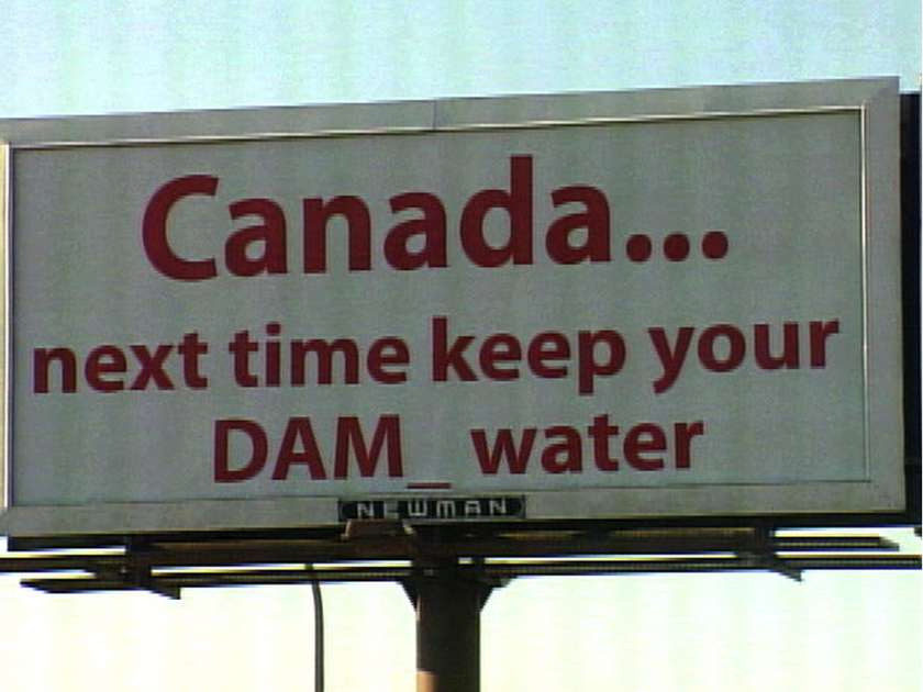
Minot Billboard Summer 2011 |
| The Trauma | Mantitoba
Blames Sask. |
| Pay Attention | The Then Mayor ? Blame |
"We rely on officials who are cautious and careful and simply said 'Look, we've got to make sure the integrity of those dams [is] protected."
Saskatchewan Premier Brad Wall
Unreal You Had The Dams At Max Level For Months In 2011 - Thats How You Manage Dam Integrity!
Minot TV Station Blames Sask.
Canadian's Blaming Canadian's
Dam To Be Blamed
Sask Watershed Authority And There Lies The Blame For This Entire Mess
The US Wont Be Too Pissed Off
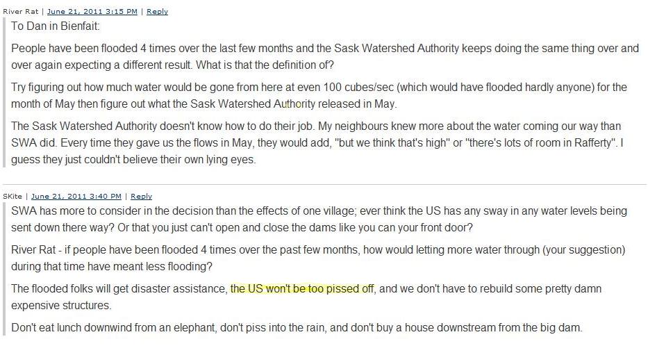
Drain & Dismantle The Rafferty Dam Club
SWA Annual 2011 Review
"Maximizing the benefit for
any one purpose generally means sacrificing benefits of
another purpose. Stakeholders whose benefits
are not maximized by operations are often critical of operation decisions especially if they have sustained damages"
That Is A Real Equity Builder Statement
are not maximized by operations are often critical of operation decisions especially if they have sustained damages"
That Is A Real Equity Builder Statement

| A Dry Dam Return To Top Of Page |
Three Dam's In Canada To Manage The Basin
With Minot Being The Bulls Eye For Mismanagement
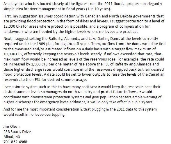
Jim Olson is correct in his recent Rotary Article that Minot can be protected by enhancing the existing structure of dikes and dams:
Minot does not need a massive government program from Washington, a large flood-way, or a huge dike system for the local government to maintain for infinity
| Seeking Answers | Jim Olson Article |
A once in 400 year event and you needed to restrict the cfs down through Minot
at 8000 to 12000 cfs to get past the event, a dry dam would have done the job.
How many 100,000's of acre feet could you slow down in that valley?
How much would it cost to grade Highway 5 with water control gates, 150, 250 million?
This billion dollar flood control in Minot is a joke and it is years since 2011 and nothing is in place.
Except for the $26 million dollar flood wall at the water treatment plant where as most of it could have been
built of clay, since it worked well in 2011 and there is nothing on the other bank for flood control.
The Great Wall
Dry Dam's - No they were never built to be dry dam's another misbelief told to or started by American's.
The long battle over and during construction was the dam's would never fill with water, because of the arid region and drought.
George Hood would swim naked in both dam's when completed.
The Dam's - Politics Not Science
| USGS -
Links Return To Top Of Page |
No one could foretell the coming flood, yet the USGS builds this huge website and study
of when it might happen again, how much money did they spend on this?
Of course it will happen again, no one manages it!
| The Souris Story | The Study |
| A Stochastic Simulation | Will It Happen Again |
The Odds Of It Flooding Again In Minot Are A Million Times Greater Then President Trump Ever Making America (Government) Great Again
The City Will Die If The River Continues To Do What It Has Done Over The Past Years, If The Dam Isn't Built The City Will Disappear As A Viable Part of The State - Chet Reiten - Dec. 1980
He didn't get the dam he wanted, what he got was the dams of contention That 31 years later would full fill his statement and his vision.
The 1976 Flood Was Contained By Men Who Took Action - 35 Miles Of Dyke Built & Shored Up, New Channels Cut, In Two Weeks Using Some 459 Pieces Of Equipment
The City Came First - Jim Ruyak, Max Noah, Chet Reiten, Art Link, Milton Young, John Arnold
The New Elementary School In Minot Should Have Been Dedicated To These Men " The Spirit Of 76" The Nation's Bicentennial
The Burlington Dam Capacity would have been 633,000 acre feet, plus a raised Lake Darling of 110,000 acre feet (1977 Price Tag Of $92 Mil. For Both) - and the 377,800
acre feet in the agreement. Giving you 1,128,000 acre feet of storage, you could have contained the 2011 flood with some take action management.
| Bad
Math & The Magic Number Return To Top Of Page |
One has to stop and ponder how it is in 1976 that the people in the know were able to tell Minot weeks in advance that they were looking at 10,000 cfs ?
Bare in mind you did not have the following! No Rafferty or Alameda dams, No four foot extension of Lake darling, No massive federal debt, No multi billion
dollar state Legacy Fund. What you did have were men who had a choice, flood the town or bite the bullet and fight like crazy and make a mess of epic
proportion and keep it dry. Better to clean up dust then mud! In 2011 you have this attitude, this misinformation, its as if the tools in the modern tool box
did not exist. No one would take the Mouse by the horns and start clarifying what was happening. It was like a social media event that got in the way of there
daily events. For if it was not, then why weren't the dots connected all the way back to the fall of 2010? They, the people in the know all seem very able after
the fact to connect the dots, to publish numbers and data, they seem to miss the real data of those numbers. No one took charge.
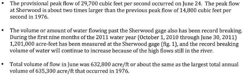
From October 1 2010 to June 30 2011 - 1,201,000 acre feet moved down the Souris River
1,201,000 acre feet divided by 273 days = 4399 acre feet a day
4399 divided by 24 hours = 183 acre feet a hour / 183 divided by 60 minutes = 3 acre feet a minute
3 acre feet times 43,560 is 136,080 cubic feet - divided by 60 seconds = 2268 cfs down the souris.
That never happened, the focus by those in the know is to keep the dams full - not available storage.
If you leave June 2011 out of the equation
568,200 acre feet divided by 243 days = 2338 acre feet a day
2338 divided by 24 hours = 97 acre feet a hour / 97 divided by 60 minutes = 1.6 acre feet a minute
1.6 acre feet times 43,560 is 70,733 cubic feet - divided by 60 seconds = 1179 cfs down the souris.
That never happened either. You have had record setting rains and snow fall all the way back into the fall of 2010 and you have the dams full
as you go into March, April, May of 2011. No one does nothing to reduce the risk of impending doom. There is no treaty storage at the Canadian dam's.
Along comes June, still no one does anything.
Flashback to 1976 and no dam's and the flow was higher in 1976 and Minot was foretold of the flow and the city was saved, in 2011 no one does nothing.
632,800 acre feet divided by 30 days = 21093 acre feet a day
21093 divided by 24 hours = 879 acre feet a hour / 879 divided by 60 minutes = 14.6 acre feet a minute
14.6 acre feet times 43,560 is 638,073 cubic feet - divided by 60 seconds = 10635 cfs down the souris.
Your right back where you were in 1976 and still no one does nothing. A 5 year old with a 2 dollar calculator could have averaged this out month over month
of inflow in comparison to 1976 calculation's and current levels of the dams and told Minot hey Iam 5 years old, but just in case you should look to move 10,000 cfs
because the other 5 year old's wont drain their dams, and those dams didn't exist the last time around, so lets play safe at 10,000 cfs.
No you did not need a crystal ball to see what was coming, you just needed a 5 year old to look outside and at the dams!
This Hype about filling Lake Darling every 3.4 days - Did they ever think to drain it every 4 days? Capacity 110,000 Acre Feet
110,000 acre feet divided by 4 days = 27500 acre feet a day
27500 divided by 24 hours = 1146 acre feet a hour / 1146 divided by 60 minutes = 19.0 acre feet a minute
19.0 acre feet times 43,560 is 831,874 cubic feet - divided by 60 seconds = 13864 cfs down the souris.
With a little help from the other kids you could have brought that down over 5 days, 6 days and stayed at 10,000 cfs.
If someone would have done there due diligence and stepped up, a cfs flow would have been demanded to anticipate inflows and match
them day over day as the thaw took place. How many hundreds of employees work for the state and fed who get paid to be in the know
and only a handful were ringing the alarm bell. The dams in Canada are about 2 hours drive from Minot, did the city send staff to look at them?
Did the state?, did the media?, not until the end.
One Acre Foot - is an area of one acre - one foot deep in water - which has 43,560 cubic feet of water
It would be the size of 11.4 - 53 foot freight container's - In 1976 every second 2.6 containers flowed by, in 2011 7.0 flowed by.
After The Flood
All the Dams Of Contention did in 2011 was create a mismanaged mountain of water
To cause a mismanaged flood to Minot that was less water then 1976!
One 5 Year Old Gets It
The Magic Number For The Mouse River Is 10,000 cfs
Four massive dams in place and the bureaucrat's cant find a common historic mean number to shoot for!
In the end they created a panic flow flood of water and bureaucracy to epic proportion
Here is another study of the study and hiring someone to keep studying the study of the study - Public Comments Of The Study On Page 173
Plan Of Study
Jim Olson & The Flood
As A Investor One Should Always Do Due Diligence To Protect Oneself.
One Can Only Interpret The Unknown Right Side Of The Chart By Gageing The Known Left Hand Side
| Bureaucrat's Return To Top Of Page |
Here Is How The Bureaucrat's Finally Managed The Dam's
Rafferty Capacity 511,000 AF - Alameda Capacity 152,000 AF - Boundary Capacity 49,100 AF - Lake Darling Capacity 110,000 AF
Total Storage Capacity Of 822,100 Acre Feet - 1,201,000 acre feet moved through the system from October 1-2010 to June 30-2011
In that time they had to manage 378,900 acre feet more then they could store - 378,900 acre feet over 273 days is 700 cfs & they couldn't do it.
378,900 acre feet in the 30 days of June 2011 is 6368 cfs and they couldn't do it. - Flow at Minot June 2011 27,000 cfs and They Did It!
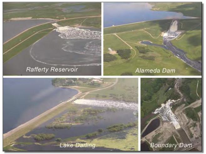
Two Different Video's On June 19th 2011 - They Finally Match Out Flow To In Flow & Send Minot To Hell
In Long Video Author Says " Here Is Rafferty Dam Built By Sask Power" at 3:10
| 19000 CFS Short Video | 19000 CFS Long Video |
The Photo's Are Of The Dam's Being Managed In June 2011
Manitoba 2011 Review Of Flooding
Page 110 Souris River - Page 128 Conclusion - Modeling Flows From Westhope - Over Whelmed - They Were Out Of Control
"Erroneous discharge measurements were left unaddressed for extended time periods without trying to reconcile differences in reported flows"
The Report
Flow Chart - For No Common Sense Operating Agreement - Dam Pool Levels - CFS Releases
At Souris River Dam's Since 1986

| Minot
Enhanced Flood Control Return To Top Of Page |
Estimated Cost Without Inflation & Time $820,000,000.00
For anyone who has lived in Minot for a lifetime it is a never ending theme, Flood Control. From 1969, 1976 and the grand debacle of 2011.
You have watched this town be ripped apart and another ton of money be threw at it. From the contention of the Burlington Dam
To the we are protected forever disaster of the Rafferty Alameda trade-off. For over a decade everyone believed you could not flood Minot.
This time the money is more then a ton.There is no $820 million dollars to finish this in 3 to 5 years. Maybe not in 20 years.
It is not the answer, it does nothing to protect upstream to Burlington and nothing downstream to the Canadian border.
2019 - May - Hold That Phone Some More - The State legislature Has Given Minot $82.5 Million Dollars
$921 Million Dollars Since 2011 & City Debt Has Increased By $212 Million
Total Received = $1,133,000,000.00 One Billion and One Hundred and Thirty Three Million Dollars
At a population of 50,000 That is $22,660.00 for every man, women and child in Minot
$83 Million
2017 - June - Hold That Phone Some More - The State Water Commission Has Given Minot $6 Million Dollars
$838 Million Dollars Since 2011 & City Debt Has Increased By $212 Million
Total Received = $1,050,000,000.00 One Billion and 50 Million Dollars At a population of 50,000 That is $21,000.00 for every man, women and child in Minot
| $1 Million | Plus $5 Million From The County |
2017 - April - Hold The Phone - The 2017 Legislature Just Gave Minot Another $193 Million - Minot Will Have To Increase Debt By $112 Million To Match Their Share
$832 Million Dollars Since 2011 & City Debt Has Increased By $212 Million
Total Received = $1,044,000,000.00 One Billion and 44 Million Dollars At a population of 50,000 That is $20,880.00 for every man, women and child in Minot
With The Inter Modal Yard Bankruptcy & Parking Ramp Rabbit Holes At Least Another 25 to 35 Million In Taxpayer Debt
2016 - Minot Has Received Roughly $414 Million Dollars Since 2011 In Federal (Taxpayer Debt) Plus Another $225 Million From The State Of ND
$639 Million Dollars Since 2011 & City Debt Has Increased By $100 Million
Total Received = $739 Million Dollars At a population of 50,000 That is $14,780.00 for every man, women and child in Minot
The City wants some 700 to 900 million for flood control - What happened to the $739 Million
The Canadians Managed The Dams In 2017 & Minot Is Going To Build This Stupid Flood Control
The Engineering Company Will Take In Some 30 to 40 Million While The USACE Has Some 37,000 Employees Sitting On Their Ass
There are three thing's that come to mind when you when you look at this illogical project!
1. What's wrong with what you have? Not much, bad management of the dam's and build a dyke system that is permanent.
You had faith in this system for so many years and it worked. No one ever stress tested it. No one ever ran a drill on manageing it.
No one ever checked the plan (There Isn't One) for a worst case scenario that was as obvious as a bulldozer coming down the road in 2010 - 2011.
Just this simple management strategy as Jim Olson suggested back in 2011, all the data above support's it.
He and his family member's lost their houses in the flood, so he's not just whistling Dixie down by the river.
Jim Olson & The Plan
For the money Minot does not have and the money Minot has lost on this flood they could hire a person that does nothing but follow
these dam's and understand them. They could have a law firm on retainer to petition a court to force the Canadian's and the CORP
To Manage The Dam Dam's. The bureaucrat's will never ever risk their job's to save Minot.
All the data above is clear, nobody would stand up and nobody had a clue as to what they were doing in 2010 - 2011.
2. Why is the Engineering Company that is engineering the project the cheer leader for the project?
Go Team Go
More power to them, but shouldn't it be the citizens of Minot and the basin leading the charge on a plan for fixing the problem?
"It is estimated $101 million is the administrative cost of the project, including planning, engineering, and program management costs."
That's shark tank valuation money. The state has how many engineers employed? The CORP has 37,000 employees, that's 740 employees per state.
ND Water Commission Employees
Imagine being in the loop on a $100 million dollar revenue stream, YAHOO.
The Detailed Plan - Cost & Timeline & Other Unfunded Project's
Not Only That But Why Aren't You Doing The Fast & Easy Stuff First - Dykes, Dykes, Dykes.
As the man said, do the fast and easy stuff first, because that's where the money is.
Leave the hard stuff for last so you have more time to get it done right and you have money to do it.
Engineering Cost
.3. Why Do We Have A US Army Corps of Engineers
With some 37,000 personnel and a annual budget of $4.5 Billion dollar's?
The USACE
Pre 2011 Hype Belief - Rafferty Alameda trade-off
In 1976 a huge amount of clay was moved for dykes and channel's were cut and coffer dam's built.
This clay moving was done in 1969 and again in 2011 for as many times as clay has been hauled in and out of Minot
Why weren't the old channel's buried and the main channel dug wider and deeper and diked permanently for a cfs flow of 10,000 to 12,000.
Oh no, we cant have that to look at, it blocks my view of the river and the hype belief in the Rafferty Alameda trade-off.
How many people were ever told the crap behind the contention no dam in my back yard hype deal?
Why wasn't the channel of the Des Lac ever straightened out as it comes through Burlington?
Why wasn't the channel of the Souris ever straightened and set up for 10,000 to 12,000 cfs coming from Burlington.
The Flood Control of Minot should have never stopped.
Post 2011 Hype Belief - Rafferty Alameda trade-off
Oh My God there really is not some smart guys sitting at control desks at the dams in Canada to protect the valley as I walk through the trees? No never was.
Oh My God the dams in Canada aren't big enough to contain global warming, we have to save Minot from doom. No same flow as 1976.
Oh My God we have to spend $820 million to haul clay in again to build dykes that we have built how many times! This time leave them!
"Better communication between
the U.S. Army Corps of Engineers and the Saskatchewan
Watershed Authority,
Including detailed plans and
notice, could have allowed for more effective releases from
Lake Darling Dam and reduced the excess flows crossing the U.S.‐ Canada border."
Unreal - No One Spoke To The Canadian's Or Went To See Them, 37,000 Corp Employees & No One Called - Hey You Got Water
Lake Darling Dam and reduced the excess flows crossing the U.S.‐ Canada border."
Unreal - No One Spoke To The Canadian's Or Went To See Them, 37,000 Corp Employees & No One Called - Hey You Got Water
| Dam Risk Reduction Report Pg. 10-11-12 | Jim Olson Article |
Yes with this flood control it still wont involve anyone manageing the dams, yes that's correct!

Causeway On Broadway In 1969 - In 1976 It Was 3rd St - In 2011 Super Dyke Was To The Right In The Alley They Kept NE Minot Dry
All That Clay Hauled In Hauled Out Hauled In Hauled Out
Highway 2 East Side Of Minot - There Has Been No Work Done To Raise The Grade For Next Time
Here & Highway 52 East & The 83 Bypass You Couldn't Even get Across Town
1969 - How Many Times Do They Have To Do This Before They Get It Right?
Your Tax Dollar At Work - Lake Darling 2011- Absolutely Ludicrous!
| USACE Return To Top Of Page |
President Harry Truman’s Interior Secretary Harold Ickes observed: “It is to be doubted whether any federal agency in the history of this country has so want
only wasted money on worthless projects as has the Corps of Army Engineers. No more lawless or irresponsible federal group than the
Corps of Army Engineers has ever attempted to operate in the United States, whether without or within the law.”
The USACE
Some 37,000 Personnel & A Annual Budget Of $4.5 Billion
That is 740 employees per state and $90 million dollars per state averaged out annually.
But if each employee cost $100,000.00 a year, there goes $74 million!
They could not afford a calculator and one staff member to drive around the Souris Basin in 2011 and figure out a flood was coming?
Annual Budget Of USACE
The USACE
Annual Fraud & Waste In The USACE
Suing - Lawsuits Over The 2011 Missouri & Souris River Floods
2011 Floods
The Purposeful Flooding of America's Heartland
The Missouri River Basin
The Pick Sloan Plan - Gone To Hell In 2011
The Big Dam Era
| 2023
& Current Real Time Pool Level Data Return To Top Of Page |
2017 Is The First Year Since 2011 That Dam Levels Were High Again - They Managed The Dams - Yahoo
But They Couldn't Manage Them In 2011 - Go Figure
It is really not that hard to find current data, and this data was available in 2011. Nobody bothered to check it in 2011 or just didn't care!
The Saskatchewan Water Security Agency (WSA) wsak.ca
The Three Dam's in Canada - go to the page, click the dam you want and current level graph's at the very bottom of the page.
Current Dam Pool Level's
Boundary & Rafferty Are Connected By Channel
WSA Forecast Page
The Canadian Federal Govt.
Real Time & Historic Data For The Dams - Daily - Monthly - Extremes - Peak - Real Time - Graph - Table - Source Canadian Federal Govt. - wateroffice.ec.gc.ca
| Boundary Dam
- 05NB012 559.2 Full Level |
Boundary
Canal - 05NB038 Discharge Level's |
Rafferty Dam
- 05NB032 550.5 Full Level |
Alameda Dam -
05ND012 562.0 Full Level |
Lake Darling Dam - The Last Stop On The Flood Train
It's pool level number does not matter much, it could never control or contain what is above at the three Canadian Dam's
The Operating Plan Has Not Changed - Still Not Hooked To Inflow Or Measurement Of Water On The Ground
2020 - The Operating Plan Has Not Changed - Still Not Hooked To Inflow Or Measurement Of Water On The Ground If The Canadian's Wont Match Outflow To Inflow
At There Dam's Then Why Dont The American's Just Do It At Lake Darling? There Dam's Are Full So Just Dump Whatever is Coming Into Them - They Wont Do It!
1597.24 Winter Level - 1598.24 Summer Level - 1603.04 Over Spillway - Record Stage Recorded 2011 - 1602.23 & 1976 - 1602.48
You can pull up historic data on the USGS site - Sometimes! - Very Screwed Up Sites Compared To Canadian Federal Govt. Sites
| USGS Level | NOAA Level |
Two Newspapers That Carry Stories On The Souris River Basin - Use There Search Boxes
Keywords - Souris River - Boundary Dam - Rafferty Dam - Alameda Dam
| Estevan Mercury | Minot Local Paper |
The 549.5 Level Is The 1989 Agreement Prescribed Operating Level By February First Of Each Year
In 2011 once the water exceeded that level it just kept climbing. No management was made to control outflow to inflow.
Rafferty - 2023
The 560.2 Level Is The 1989 Agreement Prescribed Operating Level By February First Of Each Year
In 2011 once the water exceeded that level it just kept climbing, no management was made to control outflow to inflow.
Alameda - 2023
| 2011
Dangerous Dam Pool Levels Return To Top Of Page |
To Look at Boundary Levels is Irrelevant - For it is Connected to Rafferty by Channel and It Is Always Full.
It is not like these two pools had come up a foot or two in a month, they had come up 44.0 feet combined in a month.
The month's of April and May were wide open to do something about it.
How many tens of thousands of acre feet of water could have been stored and controlled in that 26.6 feet of over full?
Nobody, Somebody and Anybody Did Nothing and Anything About It.
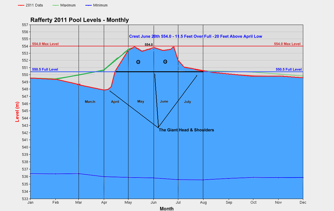
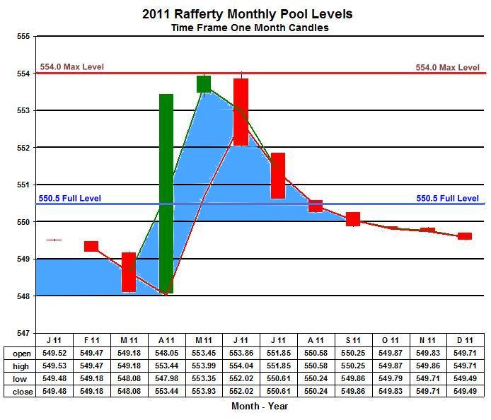
Rafferty Levels In A Month Chart
April - gets started and you are full and level is climbing, no snow melt has taken place
May - gets started and you are some 3.5 meters over full and snow melt still hasn't gotten underway and forecasts show rain
June - you are still some 3 meters over Full Level and have been playing Russian Roulette for several months
Then it starts raining and raining, BAM you finally got the loaded chamber!
This wasn't just some fluke that popped up in the course of several days or weeks, this was blatant mismanagement.
The history of the dam shows it had never exceeded its full level by more then a couple of ticks until 2011
It shot up to a unprecedented level in one month and no one thought to think or react!
The 549.5 Level Is The 1989 Agreement Prescribed Operating Level By February First Of Each Year
In 2011 once the water exceeded that level it just kept climbing. No management was made to control outflow to inflow.
Rafferty Levels In A Day Chart
The level in the month of April rose 5.5 meters, 18.0 feet, and it sounded no alarm bell to take action?
Snow melt had not taken place and you just let it keep climbing, UNREAL.
Staring down the barrel of record snow pack and moisture content in the basin they did nothing to manage the water.
There was no wiggle room for error as you went into May, their mismanagement would lead to a disaster of epic porportion
That was screaming at them with warning and no one did anything to reduce the risk.
The history of the dam shows it had never exceeded its full level by more then a couple of ticks until 2011
It shot up to a unprecedented level in one month and no one thought to think or react!
You could make the case that whoever was manageing the dam managed it like a equity trade, big sell off in March and they bought the dip and wanted to see
if they could test the first pivot ( full level ) and then the second pivot ( max level ) and had a head and shoulders ( cross recross ) and got out of the trade!
The probability of a good chart and the math of nature never lie, only the fool who cannot except the change and reverses direction when its to late.
The 549.5 Level Is The 1989 Agreement Prescribed Operating Level By February First Of Each Year
In 2011 once the water exceeded that level it just kept climbing. No management was made to control outflow to inflow.
Some 37,000 USACE employees, another couple of hundred in state's of government, big time engineering firms
That want big fees to build big flood control and no one could see what was happening in 2011.
In the words of the TV host turned President - "You're Fired"
There Wasn't 14 Inches Of Free Board Yet Alone 14 Feet Of Free Board Available In These Dams As Of May & June Of 2011
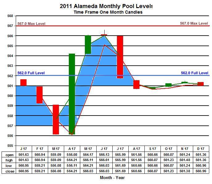
Alameda Levels In A Month Chart
Alameda Was Played The Same Way.
April - gets started and you are full and level is climbing, no snow melt has taken place
May - gets started and you are some 4 meters over full and snow melt still hasn't gotten underway and forecasts show rain
June - you are still some 4 meters over Full Level and have been playing Russian Roulette for several months
Then it starts raining and raining, BAM you finally got the loaded chamber!
This wasn't just some fluke that popped up in the course of several days or weeks, this was blatant mismanagement.
The history of the dam shows it had never exceeded its full level by more then a couple of ticks until 2011
It shot up to a unprecedented level in one month and no one thought to think or react!
The 560.2 Level Is The 1989 Agreement Prescribed Operating Level By February First Of Each Year
In 2011 once the water exceeded that level it just kept climbing, no management was made to control outflow to inflow.
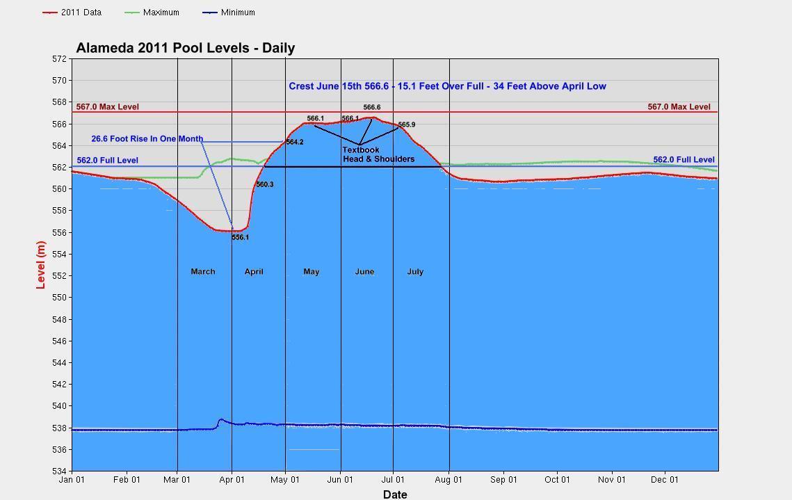
Alameda Levels In A Day Chart
The level in the month of April rose 8.1 meters, 26.6 feet, and it sounded no alarm bell to take action?
Snow melt had not taken place and you just let it keep climbing, UNREAL.
Staring down the barrel of record snow pack and moisture content in the basin they did nothing to manage the water.
There was no wiggle room for error as you went into May, their mismanagement would lead to a disaster of epic porportion
That was screaming at them with warning and no one did anything to reduce the risk.
The history of the dam shows it had never exceeded its full level by more then a couple of ticks until 2011
It shot up to a unprecedented level in one month and no one thought to think or react!
You could make the case that whoever was manageing the dam managed it like a equity trade, big sell off in March and they bought the dip and wanted to see
if they could test the first pivot ( full level ) and then the second pivot ( max level ) and had a head and shoulders ( cross recross ) and got out of the trade!
The probability of a good chart and the math of nature never lie, only the fool who cannot except the change and reverses direction when its to late.
The 560.2 Level Is The 1989 Agreement Prescribed Operating Level By February First Of Each Year
In 2011 once the water exceeded that level it just kept climbing, no management was made to control outflow to inflow.
Some 37,000 USACE employees, another couple of hundred in state's of government, big time engineering firms
That want big fees to build big flood control and no one could see what was happening in 2011.
In the words of the TV host turned President - "You're Fired"
There Wasn't 14 Inches Of Free Board Yet Alone 14 Feet Of Free Board Available In These Dams As Of May & June Of 2011
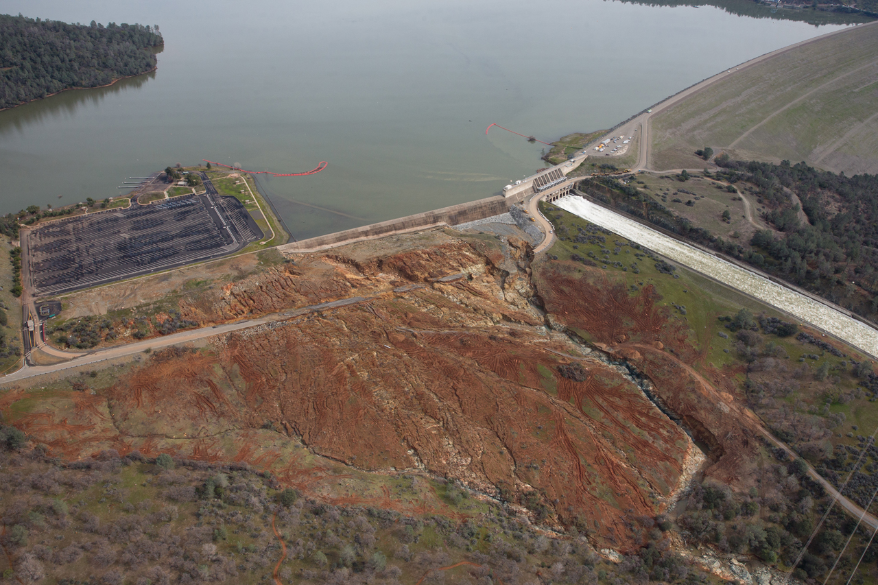
| HorrOroville
Dam Return To Top Of Page |
If you just cant warp your head around how bureaucrats manage dam's and put your life and property at risk
This dam should wake you up stone cold sober!
This monster was of ill design when it came online in 1968 - The spillway and emergency spillway don't match the size of the dam.
The spillway is so small and steep for the speed and volume of water. The last inspection was performed by helicopter.
No concrete soundings, no foot walk, just fly by. In 2005 The Fed George Busch & The State Arnold Schwarzenegger
Were advised, told and begged that the designs were flawed for re-certification of the dam. They blew it off.
You are now looking at a estimated cost of several hundred million if not more to fix it.
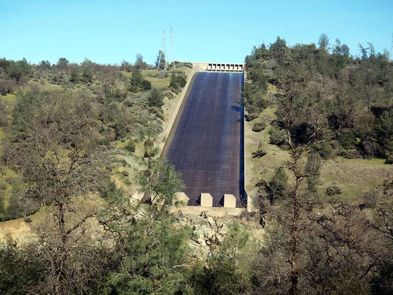
HorrOroville Dam
Most Deficient High Hazard Dams - There Are A Lot Of Them
HorrOroville Dam Spillway In 2017
The one thing that screams failure is you don't see any rebar or rebar tails in the concrete!
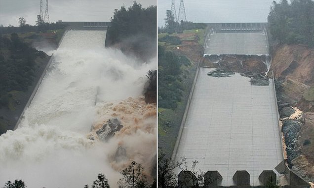
It makes no sense, no cavitation control, and it just ends with no erosion control to protect the power house pond
After the dump
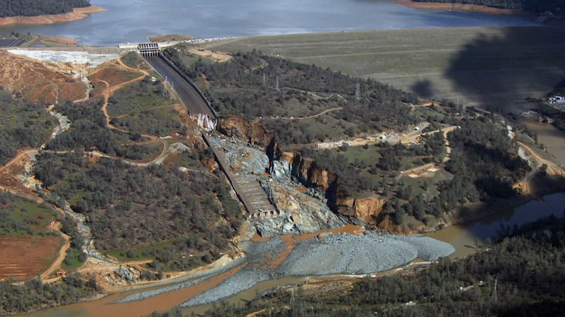
What a joke, no rebar, thin concrete, placed over loose soil when constructed.
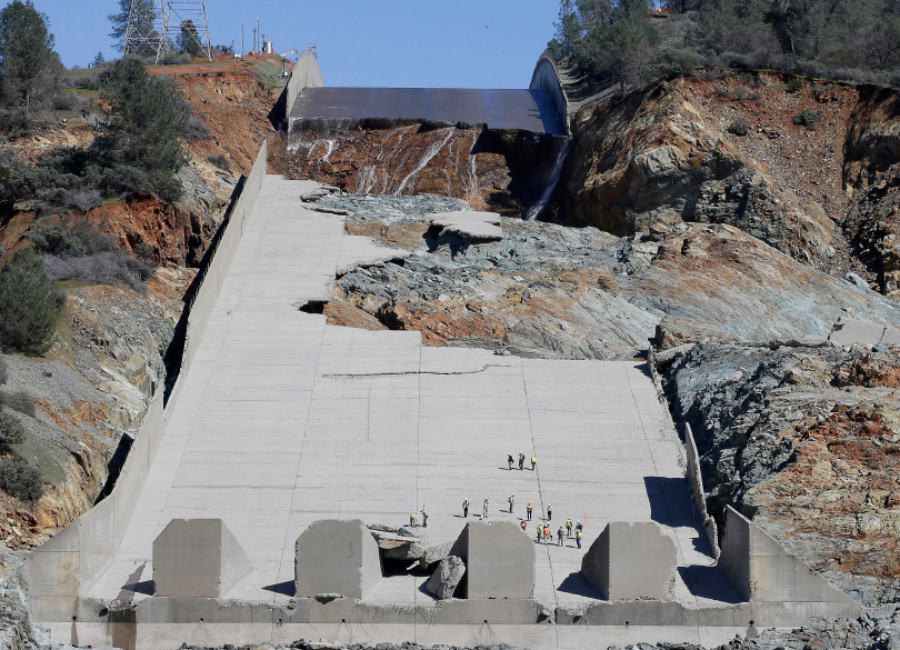
The emergency spillway looks to be about 8 times wider then the controlled spillway, you have to ask why is it built so cheap?
The concrete is sloped, angling down, it should have all been the same size wall, and why is there no concrete spillway?
All the water coming over from the left would flow back to the right before flowing down hill, what a joke.
Look at the design drawing below, it is not attached to the earth below it. Bedrock or not it should have had pilings and a concrete spillway
| Flood
Insurance & FEMA Return To Top Of Page |
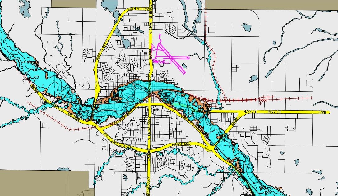
FEMA has redrawn the flood zones of Minot & area as of June 2017
FEMA - The National Flood Insurance Plan Is Bankrupt - Like Everything Fed - It Operates On Debt - Taxpayer Debt
NFIP Bankrupt
NFIP is set to expire in Sept. 2017 and congress is supposed to come up with a new bill of debt to keep it going.
NFIP 2.0
How much will flood insurance cost? Take a guess, one story says $500 a year the next story says $10,000 a year.
With NFIP bankrupt and the congress out of control, it isn't going to be cheap and or stay cheap.
One thing does seem to be for sure your rates will have minimum yearly increases of 18%.
Add that up in 5 years your rate will climb by 100%. The federal government has no business being in the flood insurance business.
It is now 2017 and Minot has received over One Billion Dollars and has done three things to protect the flood plain.
The glorified China Wall at the water plant that could have been built out of clay, the Parking Ramps and the Airport.
Three things that should have been done, 1. Lawsuits against the USACE and Canada. 2. Permanent Dikes. 3. More Permanent Dikes.
| Rates To Rise | What Does It Cost? |
The Map Is Bad - Doesn't Define Streets - No Detail Of Where Zones Start & Stop - You Have To Turn Files On & Off
Turn On Flood Control & Recovery File
GIS Minot Map
The Map Tells The Story - Blue & Brown Your In It - The Flood Insurance Trap
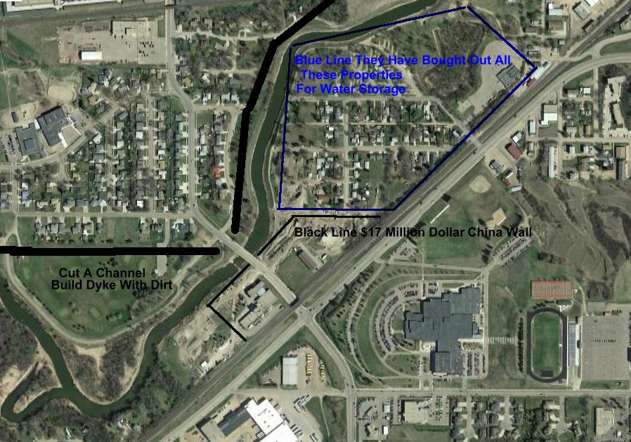
With The $17 Million Spent On The China Wall you could have probably diked the river all the way from the 83 Bypass to this point
and diked the water treatment plant and had concrete gates on 16th st. Hell for another $17 million you could probably make it to
Broadway, therefore bringing half of Minot into flood protection. Then when all is done they buy out all the houses in the blue line.
To have it for water storage after all those people had repaired their homes, who is running the circus of flood control in Minot.
Years and years have passed and the simplicity of taking the river to a diked control of 10 to 12 thousand CFS just escapes their minds.
Whats even more sad is you have two huge dams in Canada to manage this river, all that is needed is a kick in the ass every fall and winter
for someone to call the shots and watch those dam dam's and be ready to file Federal Lawsuits to have them managed.
Because In March 2011 This Is How Local Government Concerned Themselves With The Dams & Flooding
"NWS Hydrologist Allen Schlag made a power-point presentation at the Elmer Jesme Conference of Counties at the North Central Research and
Extension Center on Minot’s south edge on March 28, 2011. No one from Minot City Hall or Ward County government attended." Minot Daily News - Flashback
Flashback
| The
Contradiction Return To Top Of Page |
There Is A Contradiction Here - August 2017 - The Cheerleaders Who Want & Are Going To And Are Spending Millions To Build Flood Control
Are Now Trying To Convince FEMA That With The Mismanaged Dams Of Contention The Souris River Can Be Controlled At 5000 to 8000 CFS
It Appears That Big Money Wants It Both Ways, Pay Us To Build Something That We Know Isn't Needed! And Dont Force Insurance On The
Poor Taxpayers Who Are Going To Pay Big Bucks To Pay For What Isn't Needed And Insurance That Is Needed Because We (The Cheerleaders)
Dont Have A Frickin Clue What We Are Doing! - It Just Flies Right Over Everyone's Head.
Where does this inanity stop. You build this big buck 27,000 cfs flood control and it guarantees nothing, for if we reached 27,000 cfs we can
certainly double that with mismanagement and or the breach of anyone of the Dams of Contention. Insurance, Dykes, Management is all that
was ever needed for the Souris River. The Dams Of Contention Work, they just need to be managed.
Minot Flood Map To Be Reconsidered
One must wonder how many people left Minot when the flood occurred in 2011 and never came back, walked away.
One must ponder how many people indebted themselves to stay just to be bought out after the fact and have said enough and left Minot.
For certain how many more will say enough of this madness and leave, for the cheerleaders want 27000 CFS and they say 8000 cfs will work.
None of the cheerleader plan offers protection from the dams of contention, above and below Minot back to the Canadian border.
So as FEMA becomes the bad guy for flood maps and forced insurance all the other buildings in the Souris path will end up buying insurance.
Maybe senator Hoeven can just get FEMA to scrap the maps and like everything else just kick the can down the road.
Along with the trillions in debt and trillions in unfunded liabilities that he helps to kick down the road everyday in Washington.
2018 - A year after Maria it is revealed thousands died in Puerto Rico, your Trump FEMA tax dollar at work.
Left For Dead In Puerto Rico - An American Territory

Since Brock Long FEMA director visited Minot he has been tasked with Hurricane's Harvey, Irma & Maria. Total Melt Down.
Now those people know how it feels to be screwed over by government. The Trump FEMA FUBAR!
Where less then 3 to 5 percent of home owners had flood insurance and for all the billions FEMA and USACE spend they haven't even plotted these areas for being included or excluded from a defined
flood plain. Where in most of these area's a homeowner could have bought flood insurance for peanut's. The one thing Harvey & Irma and even the flood in Minot expose is the massive number of
American's that live and or exist in poverty and are kept in the dark about the risk by the bureaucrat's. All the while local, state and federal bureaucracies just keep sucking them to death for taxes.
Hoeven and the cheerleaders are just asking for more risk for the poor to stay in harm's way. In Minot the fix is simple, someone besides a bureaucrat or self serving idiot needs to have absolute say
over the dams of contention. As Brock Long asked is there one guy I can call about the management of the dams? No there is not. There wasn't one in 2011 and there isn't one today.
"The failure to consider the operations of Canadian dams in the development of a preliminary flood risk map for Minot
has wrongly placed as many as 1,000 structures in the 100-year flood plain, according to the Souris River Joint Board."
No, there has been a failure to consider the operations of the Dams Of Contention since the day they were built.
They were never considered after they were built to be stress tested to be drilled in a worse case scenario.
They were never considered to build Minot and other villages out to 10000 CFS for turn key protection.
They were never considered in 2010 and 2011 to be managed with precision.
They were never considered with the cheerleaders and there unneeded mega flood control scheme.
Now all of a sudden they are considered, years after the fact and headlong into the mega project they are considered.
And they are considered for all the wrong reasons, Why do we have them? Oh There The Dams Of Contention For Water Control!
| The
Tool Return To Top Of Page |
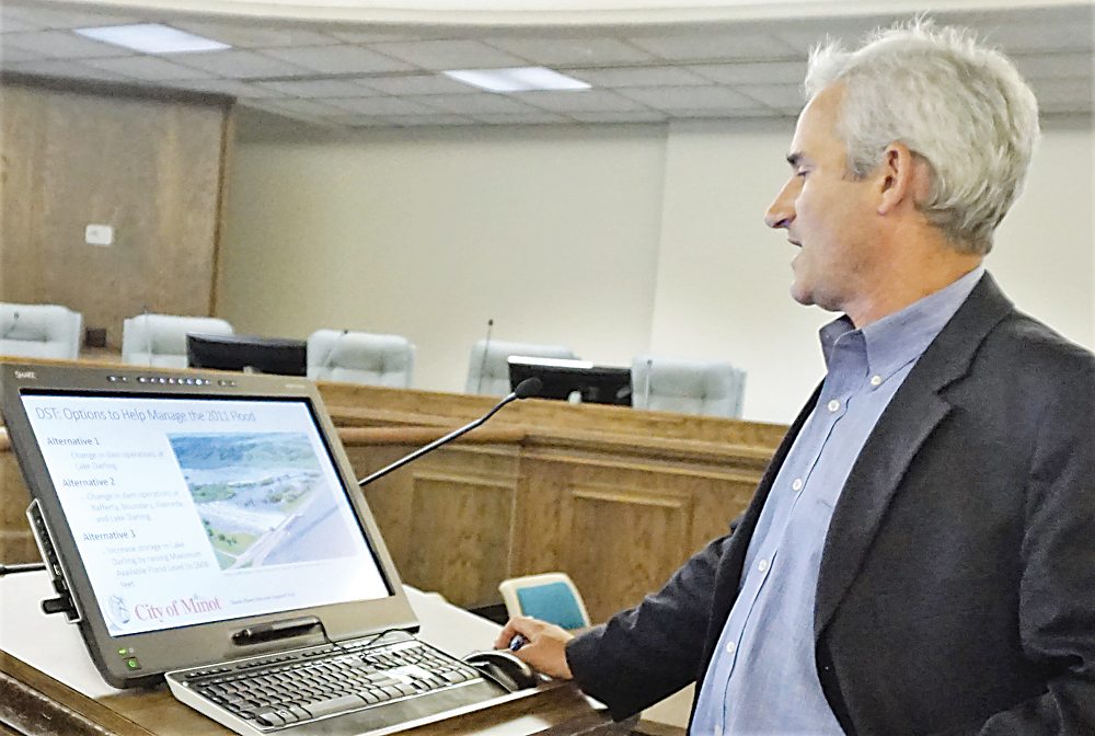
$599,000.00 For Software To Tell You That Dam Operations Can Stop Flooding - Oh Dear Lord!
This is what out tax leaders spend money on, no one managed the dams in 2010-2011 and tax leaders never even concerned themselves with flooding in the winter of 2010-2011.
One Billion & Fifty Million Dollars Later & It Is Just Now Figured Out That Dam Operations Can Stop Flooding - Bureaucrats & Good Old Boys
A First Grader Could Use The Charts & Graphs On Vanishing Minot & Tell You No One Managed The Dams - With The Visual Of A Bathtub A Pre Schooler Could Figure It Out - "Drain The Tub".
The $599,000.00 Tool - Worth A Rubber Nickel Of Common Sense
Anybody in there right minds would be ashamed to show this - yet alone pay for it. Thousands lost everything because nobody managed the dams.
“What I want to see is that you guys are going to be delivering information that we don’t already know, and right now in this particular presentation I am not sure I see that,”
council member Josh Wolsky told Wolsfeld. He noted the U.S. Army Corps of Engineers already is doing considerable work on benefit-cost analysis.“
To the degree that you guys are supplementing or adding additional value to what they are already doing, fantastic, but I guess my hope is that we see additional value above and beyond
what is already taking place, not redundancy and not confirmation of what I think we already know anecdotally,” Wolsky said.
Yea Ive managed to burn a half million dollars to build a piece of shit software the USACE already has and Donald Trump says he is going to make America great again,
I just mentally block that out, while the bag holders here in Minot struggle to cover those 1st, 2nd and third liens and ungodly property taxes and fees you all have.
Now they know their dollar cost average of losses since we figured out managing the dams would bring that down. Since we have already burned one billion
and fifty million dollars we really need a software program of what my dollar cost average has been, 50k, 100k, 200k, 300k, 400k, 500k, on a million?
Ill need another half million to get that done!
Bold New Government!
To the fullest extent of the law, we will not be liable to any person or entity for the quality, accuracy, completeness, reliability, or timeliness of the information provided on this website,
or for any direct, indirect, consequential, incidental, special or punitive damages that may arise out of the use of information we provide to any person or entity
(including, but not limited to, lost profits, loss of opportunities, trading losses, and damages that may result from any inaccuracy or incompleteness of this information).
We encourage you to invest carefully and read investment information available at the websites of the SEC at http://www.sec.gov and FINRA at http://www.finra.org.
IF YOU DO NOT AGREE WITH THE
TERMS OF THIS DISCLAIMER, PLEASE EXIT THIS SITE
IMMEDIATELY. PLEASE BE ADVISED THAT YOUR CONTINUED
USE OF THIS SITE
OR THE INFORMATION
PROVIDED HEREIN SHALL INDICATE YOUR CONSENT AND
AGREEMENT TO THESE TERMS.

Honor - Respect - Freedom - Country